
GeoServer 2.20.4 released: geoserver.org/announcements/
Please update: stable release provided to address Jiffle and GeoTools RCE vulnerabilities.

Follow
OSGeo
@OSGeo
The Open Source Geospatial Foundation... search for our local chapters around the world as well.
OSGeo’s Tweets

Jiffle and GeoTools RCE vulnerabilities
Patched releases available now:
GeoServer 2.20.4
GeoServer 2.19.6
GeoServer 2.18.6
geoserver.org/vulnerability/
#GeoServer #OSGeo
16
11

Unchecked JNDI lookups in GeoTools CVE-2022-24818
Patched releases available now:
- GeoTools 26.4
- GeoTools 25.6
- GeoTools 24.6
For more information see github.com/geotools/geoto
#GeoTools #OSGeo

4
1


2
3
7

Developers: Are the #OGCAPIs for slicing location/space consistent & complementary? OGC API - Tiles, DGGS (Discrete Global Grids), Coverages (space/time collection), & EDR (sample-able collection of data). Check out this code sprint and the our OGC Discord Server.
Quote Tweet
Developers (& Sponsors) are invited to join the OGC Space Partitions Code Sprint on May 10-12. The Sprint will focus on a set of #OGCAPI that each provide a web interface for a partitioning of space: OGC API - DGGS, - Tiles, - Coverages, and - EDR. go.myogc.org/3vn1klt

6
10

Developers (& Sponsors) are invited to join the OGC Space Partitions Code Sprint on May 10-12. The Sprint will focus on a set of #OGCAPI that each provide a web interface for a partitioning of space: OGC API - DGGS, - Tiles, - Coverages, and - EDR. go.myogc.org/3vn1klt
6
6
Topics to follow
Sign up to get Tweets about the Topics you follow in your Home timeline.
Carousel

Wow - top ten #QGIS plugins all have more than 500,000 downloads each. Top two have over 3 million! That's incredible considering that some people don't need _any_ plugins to do their work. plugins.qgis.org/plugins/?sort= #geospatial #data #opensource #python

21
64

No, it's not a late April fools joke -- #QGIS now supports animated marker symbols! Here's an animated map my 7 yo daughter and I have been putting together of her favourite animals around the world 🥳

0:40
15.4K views
10
113
520
Show this thread

Passionate about great podcasts? 🎧
You must know , a podcast for the geospatial community!
Learn more about the new #FOSS4G2022 media partner ➡️ 2022.foss4g.org/mediapartner_m
#FOSS4G #OSGeo

10
27

Have a look at this great collection of video #tutorials for #GRASSGIS version 8 by 🤓🙌
📽️ youtube.com/playlist?list=
#community #gischat

1
15
34
Show this thread


People, you are the best ❤️ The donations goal was $15k, now we're almost on $40k!
Just to remind you, there will be a conference on April 25-26 and all of the money donated goes directly to benefit NGO's helping with the war in Ukraine:

25
79

inputapp.io (aka #QGIS in your pocket) version 1.4 is released with several new features and improvements.
github.com/lutraconsultin

33
103

Who is doing interesting work with vector data?
Has image processing taken over the geo world!
If we are not doing anything interesting with the objects we abstract from imagery why are we abstracting them!
11
6
48

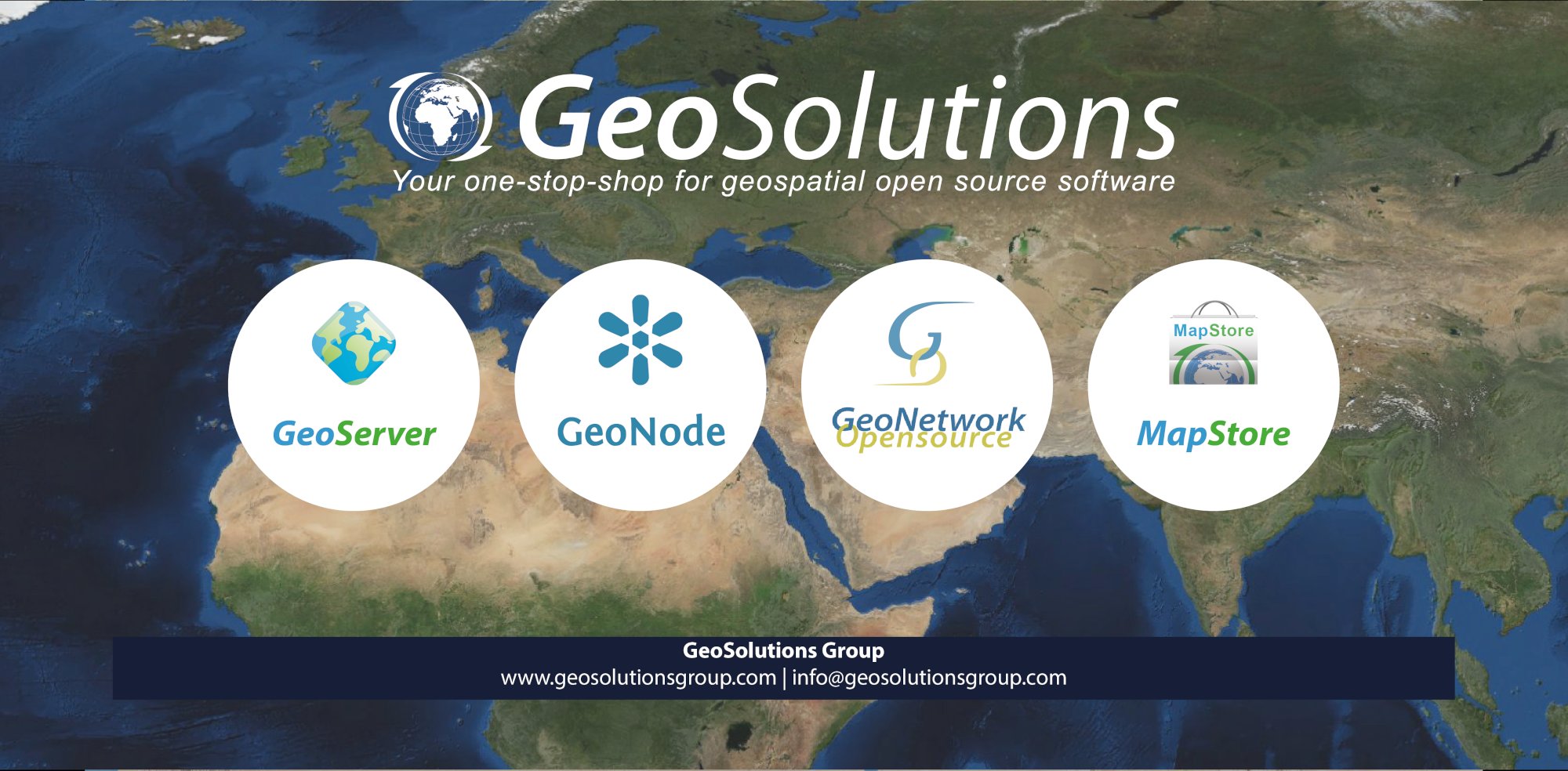
Competenza senza pari nel supportare le organizzazioni con software #opensource GeoServer, MapStore, GeoNode e GeoNetwork per applicazioni di #EarthObservation, #SmartCities e molto altro: è ufficialmente uno sponsor GOLD di #FOSS4G2022
2022.foss4g.org/sponsor_geosol

13
12


5
17

Thanks to our amazing volunteers:
🏠 41,100 buildings
🛣 680km of roads
were added to maps of Tanzania in March 2022
Find out more and start volunteering virtually to help girls in Tanzania crowd2map.org
#mondaymotivation #monday #volunteers #volunteering #dogood #NGO

16
21

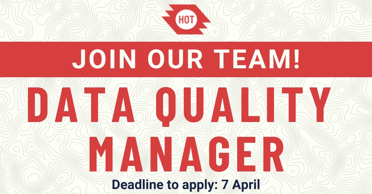
The HOT Humanitarian Data Team is hiring a Data Quality Manager to lead our Data Quality Assurance & Control work. The ideal candidate will have experience with geospatial data and leading small teams. Tmrw is the last day to apply! bit.ly/HOTJobs
#remotejobs #gisjobs
8
10
Submissions for participation are open for #SotM2022! ! You have until 25 April to send in your idea for a talk, workshop, or panel about #OpenStreetMap.
What inspiring idea will you share with the OpenStreetMap community?✨
11
15

Our Woman+ profile of the week is , A customer success engineer at Planet.
Her responsibilities revolves around #agricultural index insurance programmes using #satellitedatasets and also leads a #cropinsurance project in Kenya.
More on Hellen...linkedin.com/feed/update/ur

15
33

PDAL is not a workflow engine for processing point cloud data. PDAL is a library *for making* point cloud processing workflow engines. lists.osgeo.org/pipermail/pdal
8
32
Unparalleled expertise supporting organizations with #opensource software such as GeoServer, MapStore, GeoNode, and GeoNetwork for applications in #EarthObservation, #SmartCities and much more:
is officially a GOLD sponsor of #FOSS4G2022!
2022.foss4g.org/sponsor_geosol
14
15
More on this later ;)

1
3
57

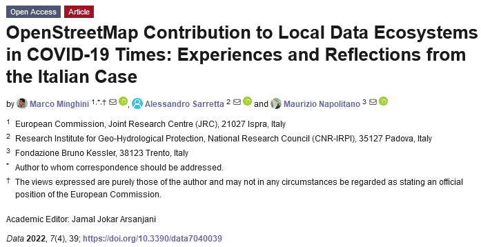
A new paper is out 🔊
"OpenStreetMap Contribution to Local Data Ecosystems in COVID-19 Times: Experiences and Reflections from the Italian Case" by , & me!
➡️ mdpi.com/2306-5729/7/4/
1
13
21
Show this thread

#SotM2022 will feature the 5th edition of the Academic Track 🎓
The track is dedicated to scientific applications of #openstreetmap and to connect academics with the larger community.
Submit your abstract by 10 May 2022! 🗓
ℹ 2022.stateofthemap.org/calls/academic/
#SotM #OSM #gischat

14
19
We're glad to announce that will be a Media Partner of #FOSS4G2022!
Remote Sensing is a peer-reviewed, #openaccess journal about the science and application of #remotesensing technology, and is
published semimonthly online by MDPI.
ℹ 2022.foss4g.org/mediapartner_r

1
7
17
Open Geosciences is a media partner of #FOSS4G2022!
is an international single-blind peer-reviewed #openaccess journal that publishes original research, reviews and news in the emerging field of #EarthSciences.
ℹ 2022.foss4g.org/mediapartner_o
#OSGeo

5
16

Quote Tweet

Find-GCP joins OpenDroneMap! The software can detect ArUco markers and automatically create GCP files. Read the full announcement: opendronemap.org/2022/04/find-g github.com/zsiki/Find-GCP
2
9


Work efficiently 🚀 – Be anywhere ⛰️ – Open anything 🔧
Get QField 2.0 now: qfield.org/get
#dataisoutside #fieldwork #qgis #gischat

2:00
4.8K views
44
120

The plan was very clear back in 2011: make it work, make it nice, make it seamless.
and wow am I proud of came out of it!
#OpenSource #dataisoutside #fieldwork #qgis
Quote Tweet
Let’s not paraphrase it, QField 2.0 is here and it is taking professional GIS fieldwork to a completely new level.
opengis.ch/2022/04/05/qfi
#dataisoutside #fieldwork #qgis #gischat

10
28
The travel grant programme is open to everyone and not exclusively dedicated to students. Learn more about all the details on the website: 2022.foss4g.org/travel_grant_p
2
4

Quote Tweet

Like clockwork (the kind that needs summertime adjustments every now and then) we are releasing Oskari 2.7! Packed with goodness and a great deal of improvements. Check out the release notes github.com/oskariorg/oska & github.com/oskariorg/oska
1
5
"All in a GIS" per la modellazione ambientale: analisi ambientali, supporto per attività di ingegneria e sviluppo di applicativi, tutto basato su GIS libero e con codice aperto.
Info: 2022.foss4g.org/sponsor_hydrol
#OSGeo

1
1

just posted a podcast with me on Cloud-Native Geospatial! Check it out at mapscaping.com/podcast/cloud- And if you're interested in learning more don't forget to sign up for the cloud-native geo outreach event at cloudnativegeo.org
1
6
25
Show this thread
Thanks, for helping us understand what cloud-native #geospatial is, where we are now and what it will mean for the future of our industry!
HT ;)
2
17
52
Show this thread

In case you missed the recent episode, I can highly recommend it.
shares an insightful perspective on #leadership, #mentorship and #diversity! 💫
Thanks 🙏 Denise and Daniel for producing such a great #leadership reference!

2
13
21

➡️ Këtë të mërkurë nga 17:30 po e nisim takimin e parë të përdoruesve të Flutter dhe të atyre që janë të interesuar të mësojnë më tepër për këtë framework.
🍻 Pas meetupit do të vazhdojmë në Pub të Prishtina Hackerspace.
Join us!
flossk.org/events/flutter

3
1

New blog post on Securing #MapServer Deployments geographika.net/posts/securing - feedback and more tips welcome #osgeo
2
5
13
Show this thread


Ayer tuve el gusto de compartir mi experiencia en el mundo #FOSS dentro del proyecto - con la comunidad de 🤗🥰
Charlamos además de todas las posibilidades para contribuir. Tu aporte vale! Sumate!🚀
📽️youtube.com/watch?v=OSeOVn
#opensource #community

5
14