
Tweets
- Tweets, current page.
- Tweets & replies
- Media
You blocked @opencholmes
Are you sure you want to view these Tweets? Viewing Tweets won't unblock @opencholmes
-
Chris Holmes Retweeted
Thank you
@opencholmes to put the spotlight on the@DisastersChart Mapper project developed by@terradue. Our first operational cloud native platform powered by@STACspec,@cogeotiff and@kubernetesio. Explore the poster presented at#lps22


 https://twitter.com/opencholmes/status/1536911555551342592 …pic.twitter.com/EZteZODND3
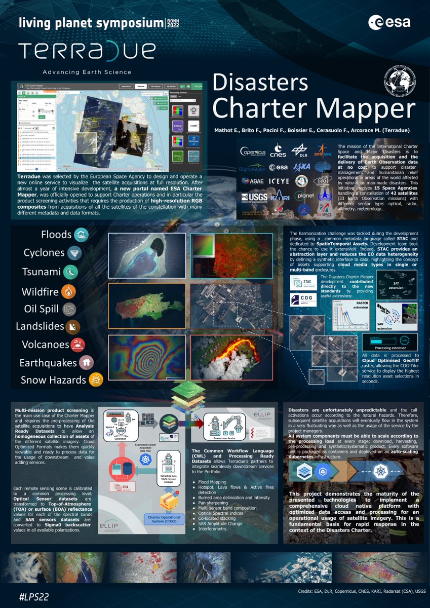 Thanks. Twitter will use this to make your timeline better. UndoUndo
 -
Chris Holmes Retweeted
Was asked to write an internal doc about requirements for API for data partners, so we can integrate data into
@UP42_ marketplace. While writing, realized that if provider uses@STACspec, that's enough for us to handle entire integration. That's how much the spec is important!pic.twitter.com/79CZDJlQzH Thanks. Twitter will use this to make your timeline better. UndoUndo
 -
Chris Holmes Retweeted
I appreciate this so much
@opencholmes &@opengeospatial. 15+ hours of quality content by 70+ speakers on cloud-native geospatial tech available to everyone - accelerating our efforts to get cloud native geospatial standards to the community.https://twitter.com/opencholmes/status/1536911555551342592 … Thanks. Twitter will use this to make your timeline better. UndoUndo
 -
The GeoParquet ecosystem continues to grow, with implementations for Python, R and now Julia (and of course C/C++ with
@GdalOrg). There also seems to be some progress in Apache Sedona / Spark: https://github.com/apache/incubator-sedona/pull/607 …https://twitter.com/GeoParquet/status/1537092867381788672 …Thanks. Twitter will use this to make your timeline better. UndoUndo -
Chris Holmes Retweeted
So many awesome talks at the Cloud Native Geo Outreach Event! Thanks
@opencholmes &@opengeospatial! Here's my talk on Jupyter STAC UI (using@STACspec in@ProjectJupyter notebook/lab), but be sure to check out the others in the playlist, too: https://youtu.be/xGE3YaGXHn8 https://twitter.com/opencholmes/status/1536911555551342592 …
Thanks. Twitter will use this to make your timeline better. UndoUndo -
Chris Holmes Retweeted
Lots of great talks about GeoParquet are now available on youtube. See
@jorisvdbossche give a great overview of what it's all about at https://www.youtube.com/watch?v=YZcwHZ-QP1g&list=PLQsQNjNIDU87yUFyKy1seaiRps389RPwk …. And then check out@kylebarron2 show off its potential on the web: https://www.youtube.com/watch?v=aDLHkZNXPk0&list=PLQsQNjNIDU87yUFyKy1seaiRps389RPwk&index=69 …https://twitter.com/opencholmes/status/1536911555551342592 …
Thanks. Twitter will use this to make your timeline better. UndoUndo -
All recordings from Cloud Native Geo Outreach Event are now up! See https://youtube.com/playlist?list=PLQsQNjNIDU87yUFyKy1seaiRps389RPwk …, and also check out my blog post recapping things at https://medium.com/radiant-earth-insights/cloud-native-geospatial-outreach-2022-recap-and-videos-2a0e80085db7 …. Thanks to
@opengeospatial for all the heavy lifting to get the videos out.pic.twitter.com/BMlIGkLhXx
Thanks. Twitter will use this to make your timeline better. UndoUndo -
Chris Holmes Retweeted
NASA is leveraging TiTiler and pgstac to provide near real-time fire information https://impactunofficial.medium.com/getting-a-firms-grip-on-forest-fires-d9c2e509542e …. Huge thanks to the whole
@STACSpec and@cogeotiff community especially@_VincentS_ and@bitnerd. Open standards and the projects built on them are what makes this possible.Thanks. Twitter will use this to make your timeline better. UndoUndo -
Chris Holmes Retweeted
 pystac-client v0.4.0 has been released!https://github.com/stac-utils/pystac-client/releases/tag/v0.4.0 …Show this threadThanks. Twitter will use this to make your timeline better. UndoUndo
 -
This is a great tool, already helping me out. Hopefully
@GeoParquet joins the mix before too long.https://twitter.com/placemarkio/status/1532761886298718208 …Thanks. Twitter will use this to make your timeline better. UndoUndo -
Chris Holmes Retweeted
Convert your geospatial files into different formats, for free, with no hard limits! We took the brains of Placemark's file import & export capabilities and made this nifty tool for everyone.https://www.placemark.io/post/introducing-our-free-map-file-converter …
Thanks. Twitter will use this to make your timeline better. UndoUndo -
Great blog post explaining the potential of Apache Arrow (and
@GeoParquet) for the geospatial world.https://twitter.com/paleolimbot/status/1532043924742848519 … Thanks. Twitter will use this to make your timeline better. UndoUndo
 -
Chris Holmes Retweeted
Taking a break from prototyping
#rstats +#gischat +@GeoParquet +@ApacheArrow to write about the motivations for using Arrow in Geospatial and how it can make geospatial computing faster for everybody! https://dewey.dunnington.ca/post/2022/building-bridges-arrow-parquet-and-geospatial-computing/ …pic.twitter.com/ATMhfReJWC
Thanks. Twitter will use this to make your timeline better. UndoUndo -
Chris Holmes Retweeted
Are you using pip to install geopandas? We have new wheels (including for windows!) for the dependency that reads data using GDAL, and your help to test those new wheels would be very welcome! See instructionshttps://github.com/geopandas/pyogrio/issues/112 …
Show this threadThanks. Twitter will use this to make your timeline better. UndoUndo -
Chris Holmes RetweetedThanks. Twitter will use this to make your timeline better. UndoUndo
-
Chris Holmes Retweeted
Looking for someone to deliver a tutorial/workshop on Cloud-Native Geospatial at our
@opengeospatial developer workshop June 17 in Madrid.@stacspec@cogeotiff@geoparquet peeps - anyone interested/available to participate in person?Show this threadThanks. Twitter will use this to make your timeline better. UndoUndo -
Chris Holmes Retweeted
I talked about http://COPC.io and
@STACspec with the@lutraconsulting team at the@qgis day presentation about new point cloud rendering features coming in QGIS 3.26. Lots of useful new stuff cominghttps://www.youtube.com/watch?v=v-ZMRpk0mv8 …Thanks. Twitter will use this to make your timeline better. UndoUndo -
I'm very excited about Planet's new developer blog. This is my first post on it, going deep on Planet & Cloud-Native Geospatial. Hoping to write many more posts there in the future. Follow along and let us know what you'd like to hear about from Planet.https://twitter.com/planet/status/1529949186136735744 …
Thanks. Twitter will use this to make your timeline better. UndoUndo -
More than happy to help out in any way that I can. Upgrading should enable more tools to access your data, like the new qgis STAC plugin and Unfolded Studio.
Show this threadThanks. Twitter will use this to make your timeline better. UndoUndo -
Hey
@swiss_geoportal - any chance you'd be able to upgrade your STAC Catalog to the latest versions?@stacindex just has https://stacindex.org/catalogs/datageoadminch#/ …, which is 0.9.0. We're working on a 'crawler' to report on total stats for the STAC network, and it'd be great to include yours.Show this threadThanks. Twitter will use this to make your timeline better. UndoUndo

 ESA EarthObservation


Loading seems to be taking a while.
Twitter may be over capacity or experiencing a momentary hiccup. Try again or visit Twitter Status for more information.