 Who Uses the Rivers?
Navigation systems across the United States and especially in this region significantly contributed to the growth and economic prosperity of our Nation. For centuries settlers in the upper Ohio River basin used the system of rivers in the Pittsburgh region to expand commerce and industrial enterprise. However, it was not until 1824 that Congress tasked the Corps of Engineers with improving navigation on the Ohio River.
Dedicated in 1885, Davis Island Lock and Dam, was the first of 53 Ohio River locks and dams, built over a 44 year period, descending from Pittsburgh to Cairo, Illinois. In 1893 the Corps opened a permanent office in Pittsburgh with the mission of improving navigation on the Allegheny and Monongahela Rivers. Today, Pittsburgh District’s navigation system includes 23 locks and dams on the Allegheny, Monongahela and Ohio Rivers.
In support of this system, the District also operates a major warehouse and repair facility located on Neville Island, housing a repair fleet responsible for major maintenance work on the locks and dams. Eight locks and dams on the Allegheny River provide 72 miles of slack-water navigation from the Point at Pittsburgh to above East Brady, Pennsylvania. Nine locks and dams on the Monongahela River maintain navigable waters for the entire 128.7 miles of the river from just above Fairmont, West Virginia to The Point at Pittsburgh. Six locks and dams on the Ohio River provide navigable waters from the Point at Pittsburgh for 127.2 miles of the river downstream to New Martinsville, West Virginia.
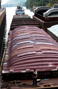
The three rivers that make up the Port of Pittsburgh are used to carry raw materials, bulk and manufactured goods for many industries in the region. The Port of Pittsburgh is the 2nd busiest inland port and the 22nd busiest port of any kind in the nation.
Commercial navigation is important to the region’s economy because river transport is an extremely economical method of transporting raw materials and bulk goods. Shipping costs for raw materials average .97 cents per ton mile by barge compared with 2.53 cents per ton mile by rail or 5.35 cents per ton mile by truck. The 37 million tons* of cargo the Port of Pittsburgh ships and receives each year provides a significant annual benefit to the region (estimated at $2.5 billion). The primary cargo in the Port of Pittsburgh is coal but millions of tons of raw products including sand, gravel and iron ore; manufactured goods; petroleum and petroleum products as well as chemicals and related products traverse our waterways. Thousands of jobs depend on the reliable operation of these river supply lines.
Industries are not the only users of the river. The locks are open to any boat. Sometimes in the summer there are lines of pleasure boats waiting for lockages on busy weekends. Almost 30,000 recreational boats locked through the Pittsburgh District’s locks in 2012 taking advantage of the improving water quality in the three rivers. Numerous excursion boats also use our locks as they cruise the rivers entertaining and educating area residents and tourists. These are only a small percentage of those who benefit from the Corps' navigation structures. Many people use the navigation pools as a lake for pleasure boating without ever using a lock and some do not realize that the miles of clear channel are created by the dams. Water sports are increasing in popularity and the water quality of the rivers has improved. Because of this, usage of the rivers will continue to grow. In many areas, gamefish are reappearing in the rivers and providing sport for large numbers of fishermen.
* The Port of Pittsburgh is defined as all of the locks and dams within southwestern Pennsylvania. (Pittsburgh District figures for cargo shipped/rec’d is 66.9 tons per year and estimated to be worth $5.6 billion to the region.)
Why We Need Locks & Dams
Navigation structures are necessary to make inland waterways viable, year-round transportation corridors. Prior to the construction of the locks and dams in the region, some river depths were less than 12 inches at times during the year and would not support commercial or pleasure boat traffic.
The natural river beds are long, uneven downhill slopes with shallow areas and deep pools. Without improvement, the depth of the water in the river would vary with seasonal rainfall and the shallow areas of the river would obstruct navigation in dry periods.
The dams which the Corps has constructed create an “aquatic staircase” in the river and prevent the river from draining in dry weather, so navigation can go on year-round. Each step on the slope of the riverbed is a pool of water extending miles upstream, maintaining sufficient depth for boats and barges. The normal flow of the river runs through these pools and the excess flows over the dam into the next pool and on down the river. However, these dams do not provide flood protection.
The entire width of the river is not used for navigation, but there is a channel in which the water is maintained at a nine foot depth for commercial vessels. Congress mandated that the channel should be at least nine feet deep.
In order to maintain our navigation structures and provide an improved navigation system for the future, the Pittsburgh District maintains a comprehensive project maintenance program including major rehabilitation as well as new project design and construction. Under current rules, the waterways industry pays half the federal costs for construction of new navigation projects and major rehabilitation of existing projects through a mechanism known as the Inland Waterways Trust Fund. Diesel fuel tax levied on commercial users of the inland navigation system finance this fund.
How Locks & Dams Work
Each dam on a navigable river – such as the Allegheny, Monongahela or Ohio – has at least one lock chamber to enable river traffic to go safely from one pool level to the next. Locks provide navigation access through the dam complex, by which vessels are lifted or lowered from one pool to the next. The lock chamber is essentially a concrete box fixed into the riverbed with two matching gates at each end that close at an angle directed upstream against the river flow. The gates can open or close only when the water level is the same on both sides. One set opens to let the watercraft enter and then closes to allow the water level in the chamber to be raised or lowered depending on the direction of travel. The other set of gates then opens to let the boat leave. Raising or lowering from one pool level to the next is called a "lift. The lift of the locks in the Pittsburgh District ranges from 8 to 22 feet depending on the length of the pool. Pool length varies from as short as 7 miles between locks up to 42 miles between locks.
The filling and emptying of the lock chamber is done by valves which control the flow of water through large, deep culverts in the lock walls. No pumping is necessary as the water flows through the culverts and into and out of the lock chamber entirely by gravity. The lock chamber never empties completely, but drops only as far as the pool level of the river downstream of the lock.