
A cold front will push through the region today bringing showers and thunderstorms to the region. A few storms may become severe, bringing damaging wind gusts and heavy rainfall.

Follow
NWS Baltimore-Washington
@NWS_BaltWash
Official Twitter Account for National Weather Service Baltimore/Washington. For NWS Posting Policy, click here: weather.gov/twitter
NWS Baltimore-Washington’s Tweets


Curious how hot it was today? Most locations saw highs in the 90s, aside from the mountains where highs were in the 80s. Maximum heat indices were between 100-110 degrees for most locales.


3
29
54
It is HOT out there. Temperatures are in the 90s for most locations, aside from the mountains. Heat indices upward of 105 degrees are possible today. For tips on how to beat the heat: weather.gov/heat

26
35
Heat Advisory in effect this afternoon for heat index values between 100 and 107 degrees. Stay cool and hydrated and remember to take plenty of breaks throughout the day today when doing outdoor activities. A stray shower or storm is possible near/west of the Blue Ridge today.


5
80
80

Topics to follow
Sign up to get Tweets about the Topics you follow in your Home timeline.
Carousel
Special Marine Warning including the Chesapeake Bay from Pooles Island to Sandy Point MD, Chesapeake Bay from Sandy Point to North Beach MD, Chesapeake Bay north of Pooles Island MD, Eastern Bay and Chester River to Queenstown MD until 9:45 PM EDT

read image description
ALT
8
8
Special Marine Warning including the Tidal Potomac from Indian Head to Cobb Island MD and Tidal Potomac from Key Bridge to Indian Head MD until 9:00 PM EDT

read image description
ALT
5
4
Severe Thunderstorm Warning including Hagerstown MD, Halfway MD and Purcellville VA until 7:15 PM EDT

read image description
ALT
18
18
Severe Thunderstorm Warning including Hagerstown MD, Halfway MD and Fountainhead MD until 7:00 PM EDT

read image description
ALT
10
6
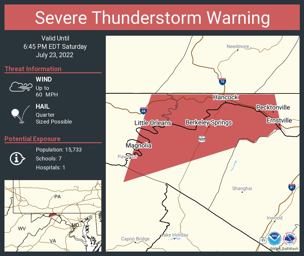
Severe Thunderstorm Warning including Hancock MD, Berkeley Springs WV and Great Cacapon WV until 6:45 PM EDT
read image description
ALT
5
7
Severe Thunderstorm Warning including Lake Holiday VA, Shawneeland VA and Capon Bridge WV until 6:30 PM EDT

read image description
ALT
4
6
Severe Thunderstorm Warning including Romney WV, Augusta WV and Old Fields WV until 6:00 PM EDT

read image description
ALT
4
3
Severe Thunderstorm Warning including Fort Ashby WV, Springfield WV and Green Spring WV until 6:00 PM EDT

read image description
ALT
3
1
Severe Thunderstorm Warning including Franklin WV, Brandywine WV and Onego WV until 5:45 PM EDT

read image description
ALT
3
Severe Thunderstorm Warning including Grant County, WV, Hardy County, WV, Pendleton County, WV until 5:45 PM EDT

read image description
ALT
3
1
Severe Thunderstorm Warning including Moorefield WV, Petersburg WV and Lost City WV until 5:45 PM EDT

read image description
ALT
4
1
Severe Thunderstorm Warning including Burlington WV until 5:30 PM EDT

read image description
ALT
6
3
Severe Thunderstorm Warning including Keyser WV, McCoole MD and Dawson MD until 5:15 PM EDT

read image description
ALT
4
1
A Severe Thunderstorm Watch has been issued through 9PM tonight for far eastern West Virginia and portions of Northern Virginia and Central and Northeast Maryland. The primary threat with these storms are damaging winds and large hail. Latest: weather.gov/lwx/

2
18
24
Severe Thunderstorm Warning including Petersburg WV until 5:00 PM EDT

read image description
ALT
5
Severe Thunderstorm Warning including Frostburg MD, Mountain Lake Park MD and Oakland MD until 5:00 PM EDT

read image description
ALT
1
9
6
Organized thunderstorms are currently approaching from the west. Areas west of the Blue Ridge can expect scattered to numerous showers and thunderstorms through 8pm this evening. Damaging winds and large hail are possible with these storms. Latest: weather.gov/lwx/

GIF
16
16
A Heat Advisory has been issued for tomorrow (Sunday, July 24th) for parts of northern VA, MD, and DC.
For the latest forecast at your location: weather.gov<<<your_zip_code>>>
Example: weather.gov/20166 for Sterling, VA

47
31
Hot again today with heat indices around 100 degrees. Stay cool and hydrated if you are out and about today. A few storms west of the Blue Ridge today may keep things slightly cooler out that way, but still in the mid 90s.

1
87
88


Another hot day today with highs into the low to mid 90s. Take proper precautions if doing activities outdoors today. Stay cool and hydrated and take plenty of breaks.


2
37
32

read image description
ALT
3
30
33
Severe Thunderstorm Warning including Arrington VA, Scottsville VA and Lovingston VA until 6:30 PM EDT

read image description
ALT
5
6
Severe Thunderstorm Warning including Hollymead VA, Rivanna VA and Twin Lakes VA until 6:15 PM EDT

read image description
ALT
4
5
Severe Thunderstorm Warning including Orange VA, Madison VA and Oakpark VA until 6:00 PM EDT

read image description
ALT
5
2
Special Marine Warning including the Chesapeake Bay from Sandy Point to North Beach MD, Choptank River to Cambridge MD and the Little Choptank River and Eastern Bay until 6:45 PM EDT

read image description
ALT
5
1
Special Marine Warning including the Chesapeake Bay from Drum Point MD to Smith Point VA, Tangier Sound and the inland waters surrounding Bloodsworth Island and Tidal Potomac from Cobb Island MD to Smith Point VA until 6:00 PM EDT

read image description
ALT
6
6
Special Marine Warning including the Tidal Potomac from Key Bridge to Indian Head MD until 5:45 PM EDT

read image description
ALT
3
3
Severe Thunderstorm Warning including Centreville VA, Burke VA and Oakton VA until 4:45 PM EDT

read image description
ALT
6
4
Severe Thunderstorm Warning including Chesapeake Beach MD, Golden Beach MD and Huntingtown MD until 4:00 PM EDT

read image description
ALT
6
9
Special Marine Warning including the Chesapeake Bay from Drum Point MD to Smith Point VA and Tangier Sound and the inland waters surrounding Bloodsworth Island until 4:30 PM EDT

read image description
ALT
4
4
Special Marine Warning including the Chesapeake Bay from North Beach to Drum Point MD, Chesapeake Bay from Sandy Point to North Beach MD, Choptank River to Cambridge MD and the Little Choptank River and Eastern Bay until 4:15 PM EDT

read image description
ALT
4
2