
Follow
Click to Follow NWSCWSUZLC
NWS CWSU Salt Lake
@NWSCWSUZLC
Official Twitter account for the National Weather Service Center Weather Service Unit Salt Lake City. Details: weather.gov/twitter
Salt Lake City, UtahJoined May 2012
NWS CWSU Salt Lake’s Tweets


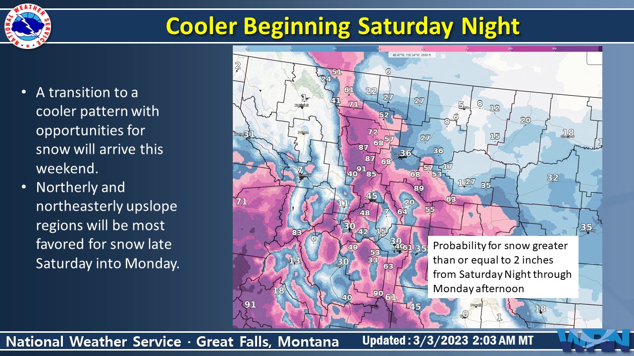
A transition to a cooler and a bit snowier pattern will arrive Saturday night. The best opportunity for accumulating snow will be Saturday night through Monday, focused in northerly and northeasterly upslope regions. #MTwx
1
5
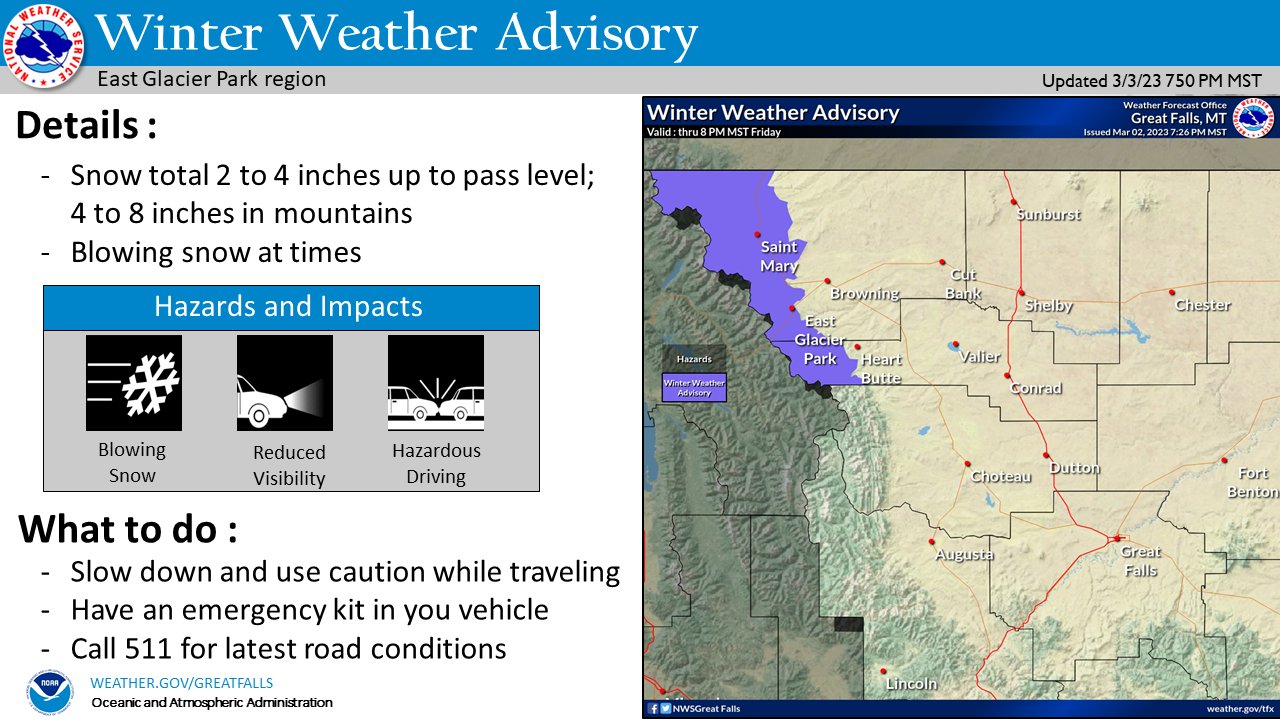
Periods of snow and gusty winds will continue in the East Glacier area through Friday evening. Be prepared for winter driving conditions if traveling. #MTwx
2
3

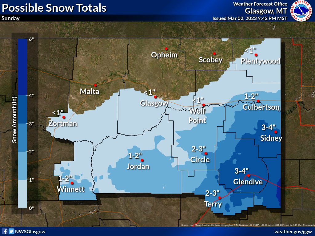
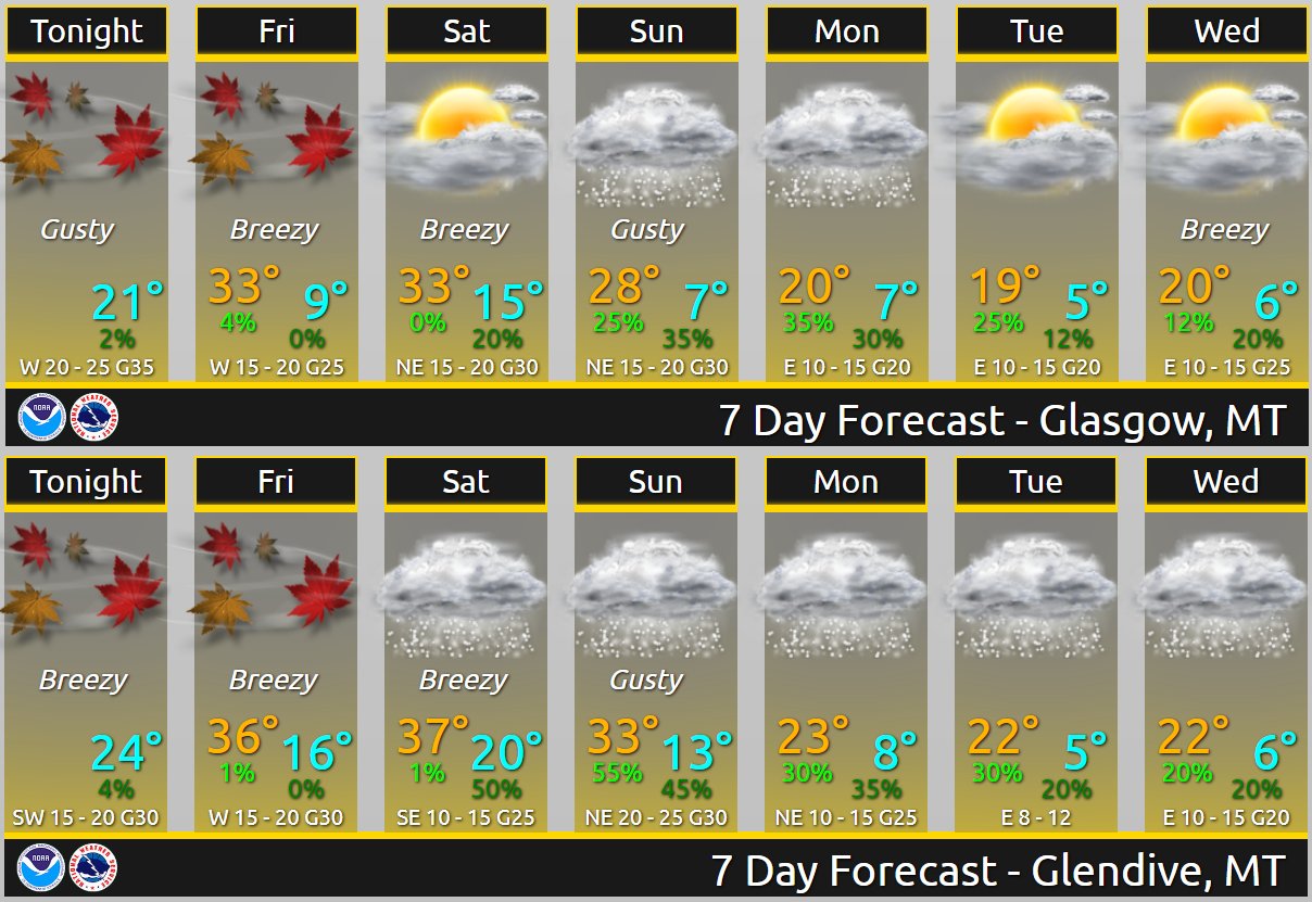
If you have travel plans this Sunday, keep tabs on a system that looks to brush the area. Right now, the best chance of seeing snow will be from Sidney to Glendive on east.
Temperatures will also get colder Sunday, and remain colder than normal through much of next week. #mtwx
1
3
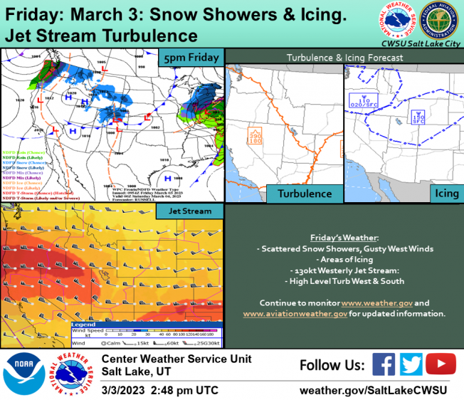
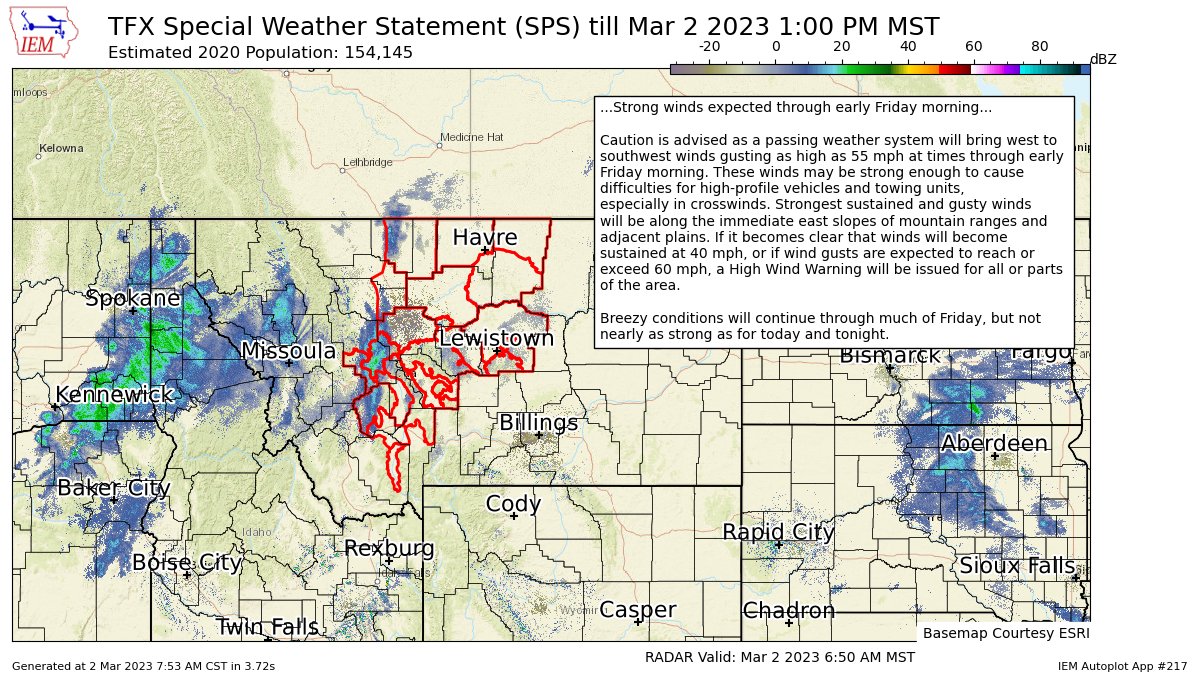
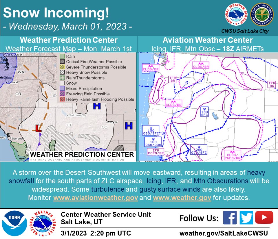
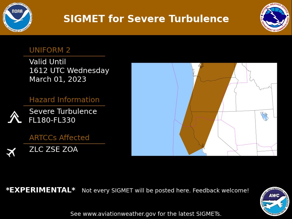
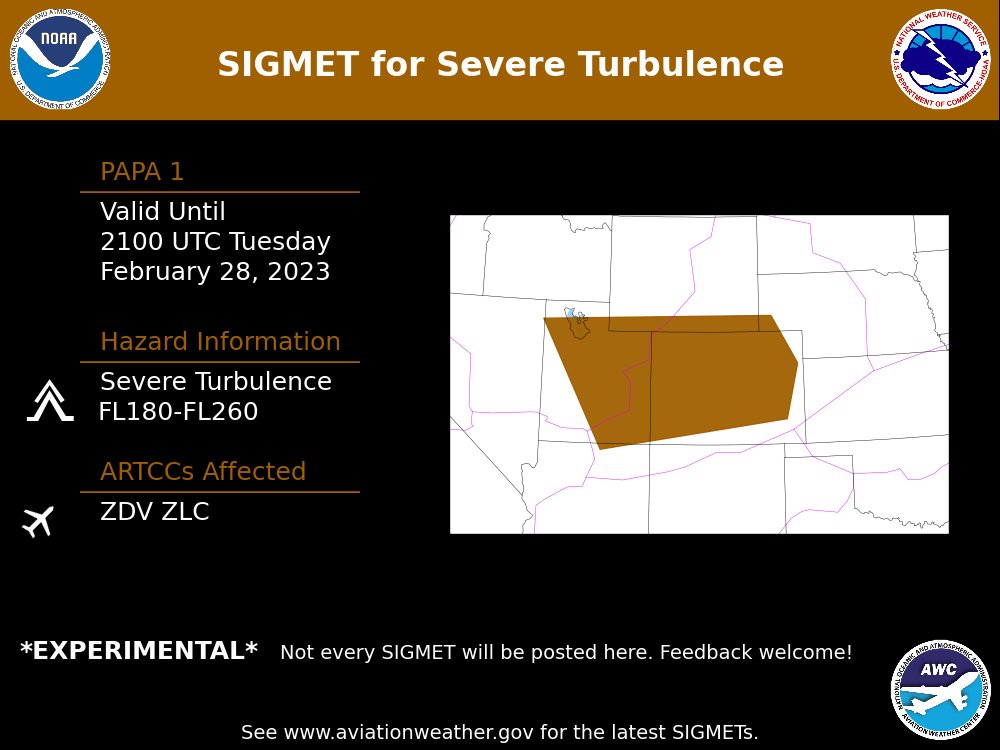
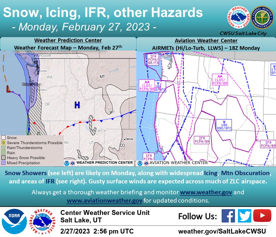
A weak upper level system will produce areas of snow showers across ZLC. Widespread clouds will also produce areas of icing conditions. A 130kt westerly jet stream will increase the high level turbulence across the western and southern sections of ZLC. #turbulence #aviation

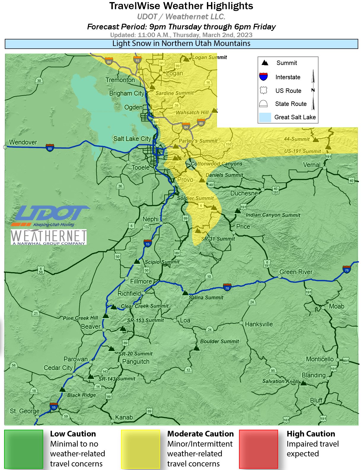
Road Weather Alert:
Light snow moves into N Utah mtns Thurs night, and fills into the valleys Fri morning. Mainly Cache Valley/bench routes are at risk for a brief slush up, with a few inches in mtns.
For more info, visit: udot.utah.gov/go/weather
#utsnow #utwx
3
4

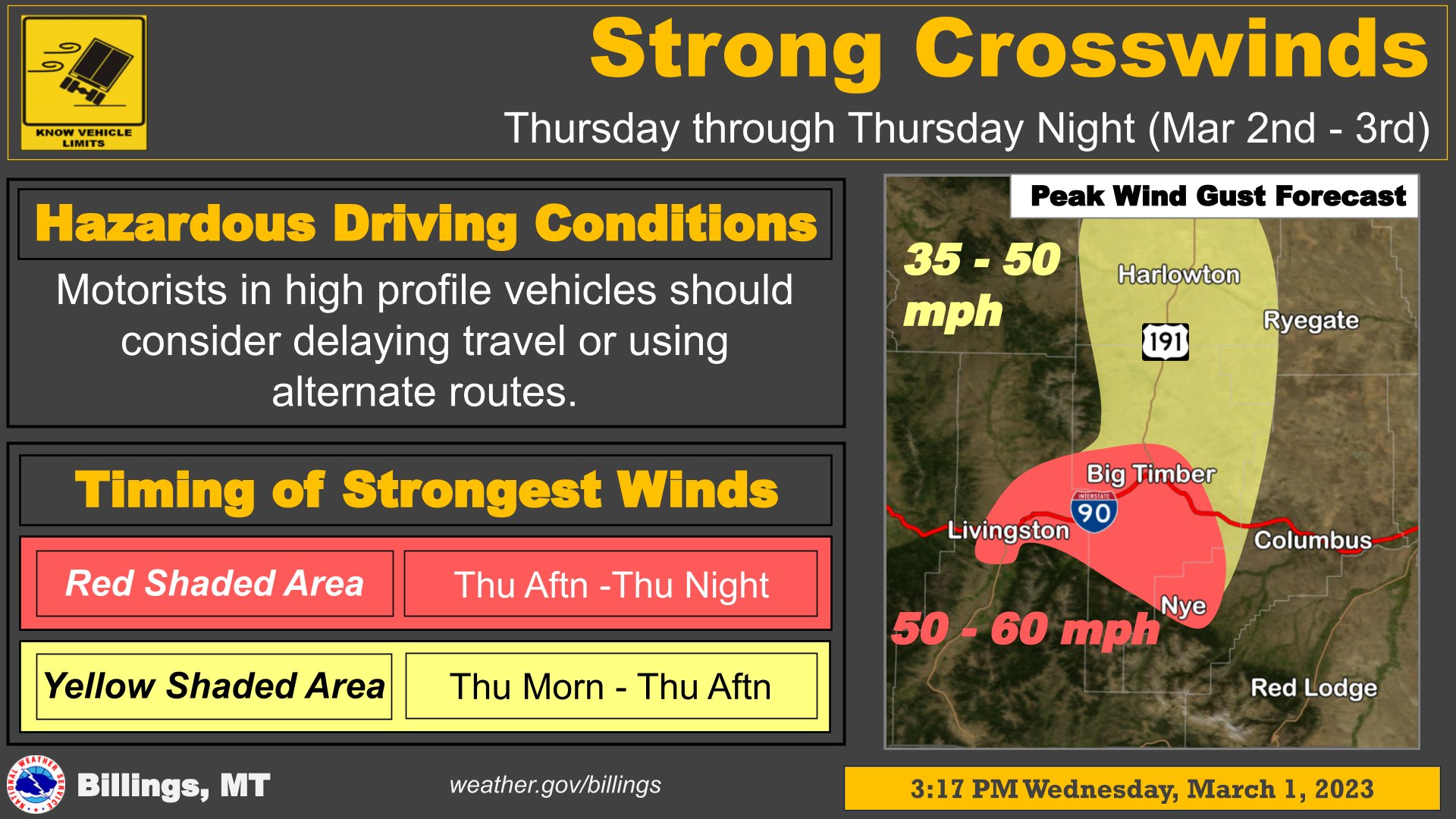
Strong west to southwest winds gusting to near 55 mph at times are expected through tonight and/or early Friday morning across much of the forecast area. Those driving high-profile vehicles or towing units especially should use caution, especially in crosswinds. #mtwx
2
2
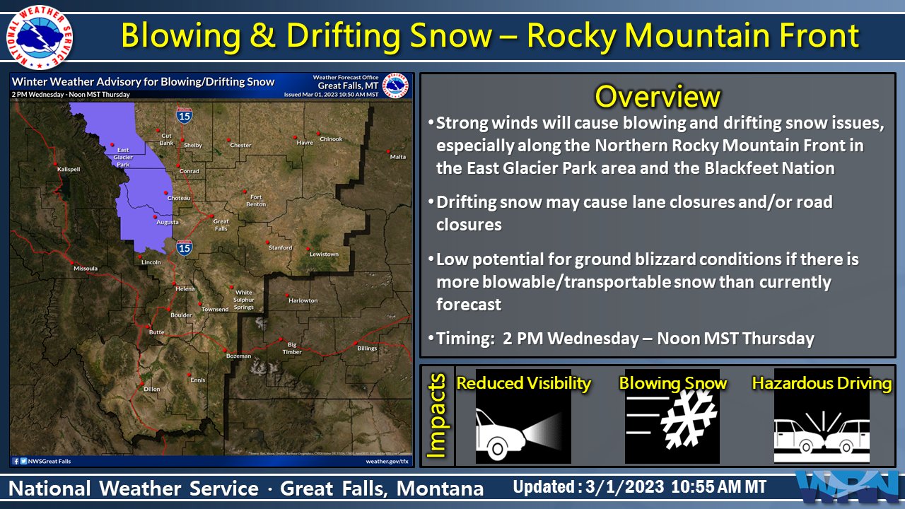
Blowing & drifting snow concerns increase this afternoon through Thursday AM as high winds set in later today. Lane and/or road closures are possible, though there is low confidence in how severe conditions might get at this time. #mtwx
2
3

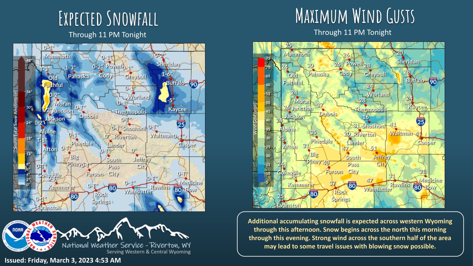
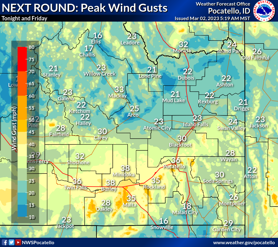
5:30 AM Thu 03/02: Here's an update on expected snow totals and peak wind gusts tonight and Friday with our next round! (Think more wind south, more snow northeast.) Stay tuned for any changes, and remember, SLOW DOWN & USE CAUTION when encountering snow or drifting on roadways.

1
1
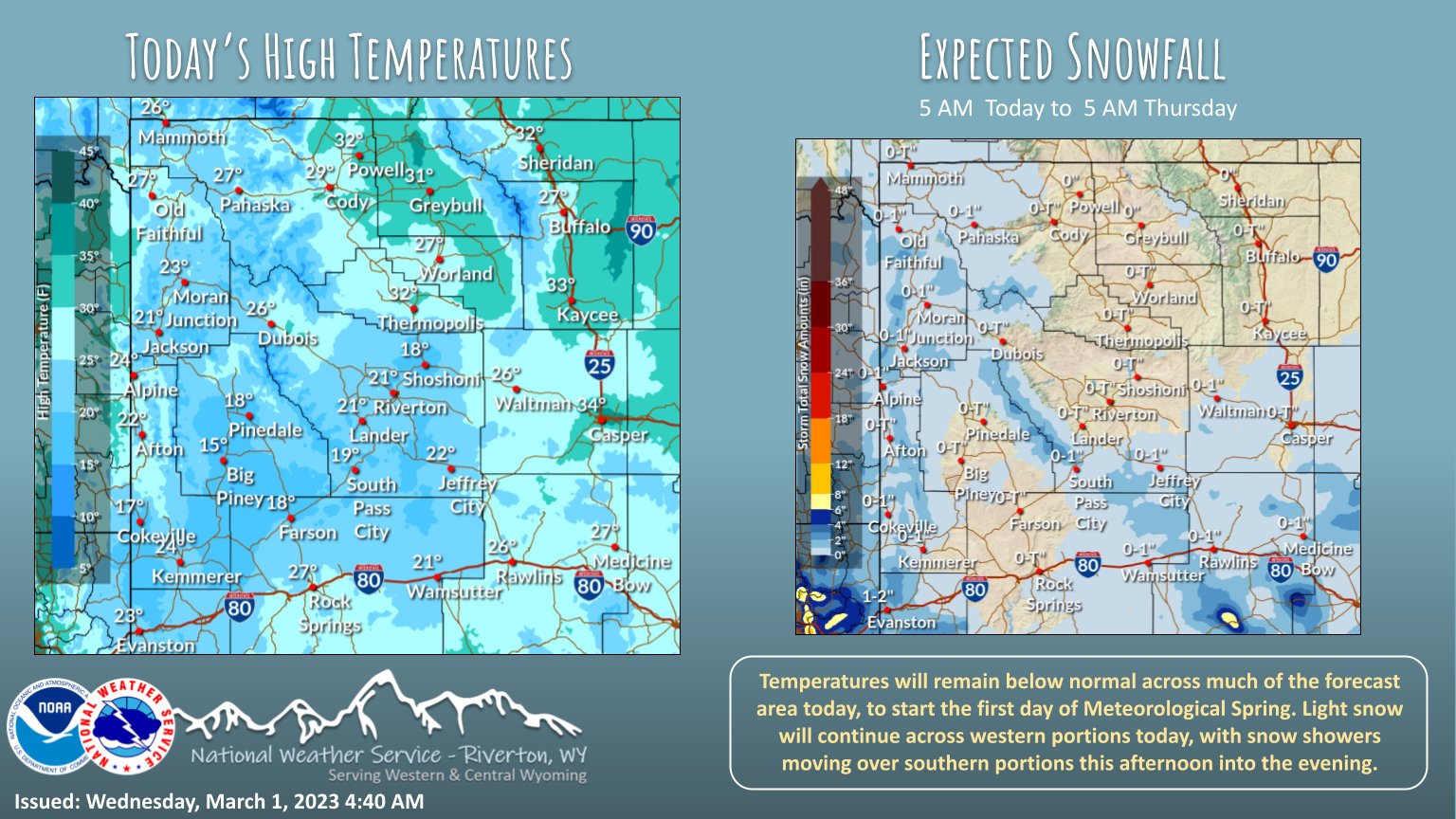
Temperatures will remain below normal across much of the forecast area today/tonight. Dry conditions today, with gusty winds across the south and Natrona/Johnson counties. Snow returns to western portions tonight, with mod/hvy snow possible late tonight/Fri morning. #wywx

2
4

Automated
SLC issues Public Information Statement (PNS) at Mar 1, 5:54 PM MST ...Preliminary Storm Information...

3
4
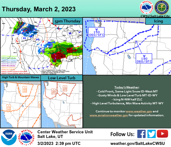
A cold front will move into Idaho and western Montana with some light snow. Gusty surface winds and low level turbulence expected over Montana. Icing will spread across the north half of ZLC. Also expect areas of high level turbulence, with mountain wave activity over MT & WY.


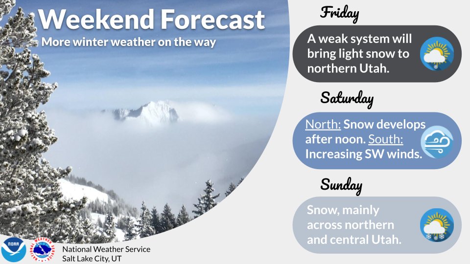
Light snow continues over western portions today. Light snow showers will move across southern portions this afternoon/evening. Temperatures will remain below normal today, to mark the start of Meteorological Spring. #wywx
1
2
A High Wind Warning has been issued for the Rocky Mountain Front and adjacent plains, beginning this afternoon through Thursday afternoon. Sustained winds of 30 to 40 mph with gusts in excess of 70 mph and 85 mph along Front. Remain vigilant for changing weather conditions.

2
5

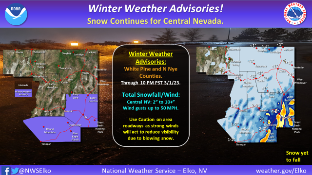
❄️Snow way! Winter isn't done yet! Though a bit of a break will be noted for many today, snow returns Wednesday. Check out the latest snow totals around the region. #UTwx
2
12
58


South winds gusting in excess of 50 mph near the north end of the Oquirrhs will result in strong crosswinds along I-80 as well as SR 201 through this evening. Those traveling through this area, particularly in high profile vehicles, should be prepared for strong winds. #utwx
6
29

A snow squall passed over western Wyoming this afternoon. The following link is to a short video of Alpine, showing how quickly conditions can change (it has been sped up slightly).

3
6
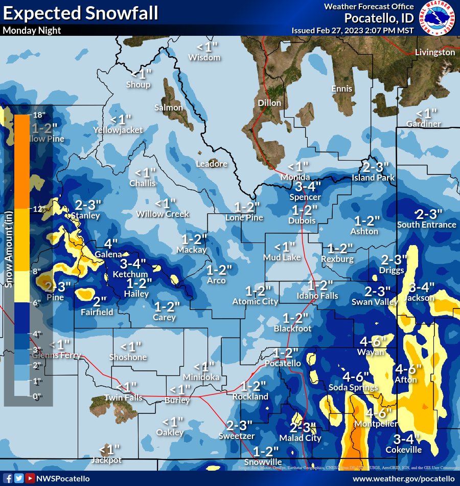
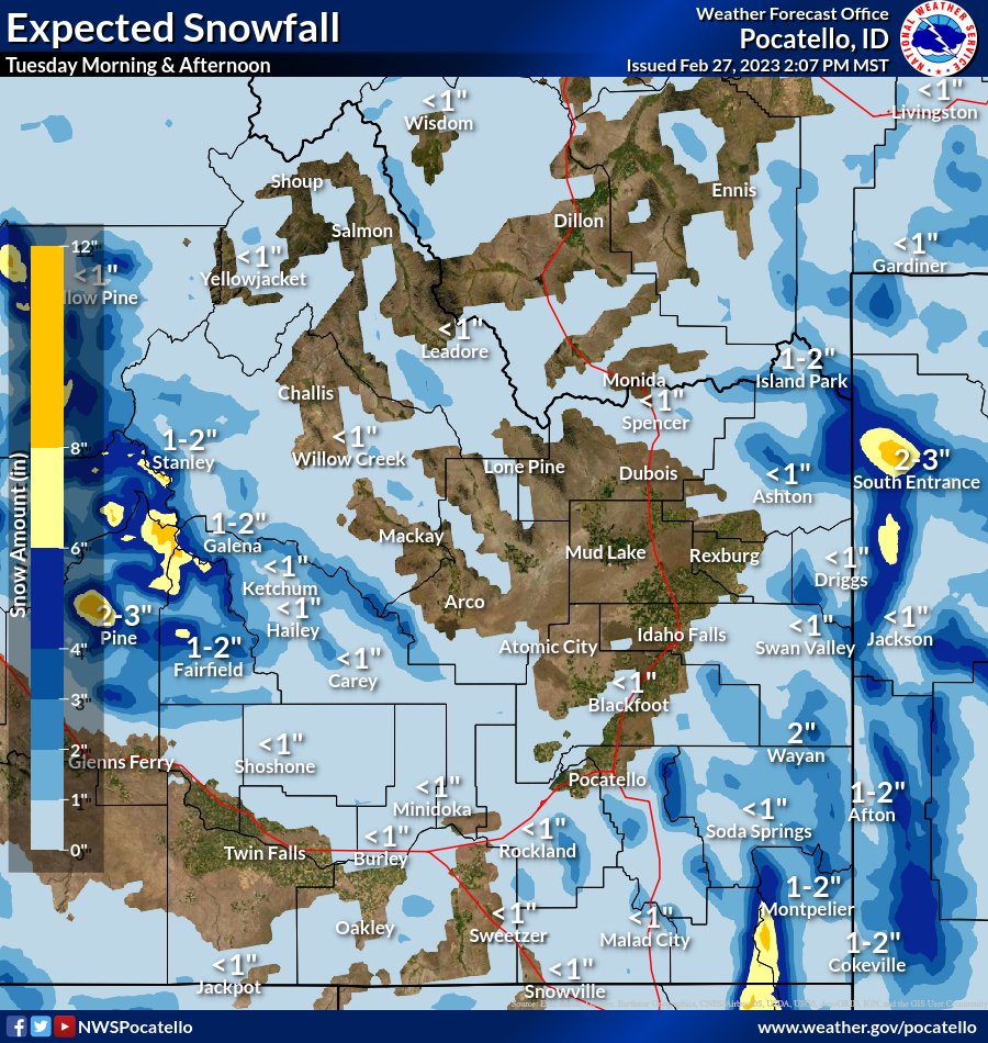
622pm 2/27: Multiple rounds of snow will persist into Tuesday afternoon, and actually into Wednesday. Focusing in on through tomorrow afternoon, expect light snow to moderate snow...with occasional bursts of heavy snow.
1
2
8
Show this thread
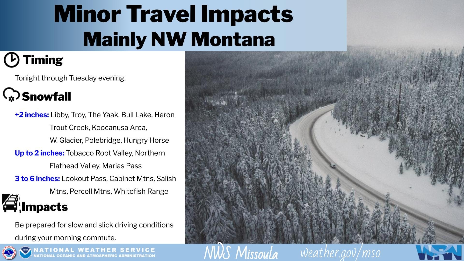
Light snow will overspread NW Montana tonight, persisting through much of Tuesday. While not necessarily a very good snow pattern for #Kalispell (up to 1 inch possible), #Libby, #TheYaak, #BullLake, and #Polebridge are likely to see 2 to 4 inches of snow by Tuesday PM.
#MTwx
read image description
ALT
2
6
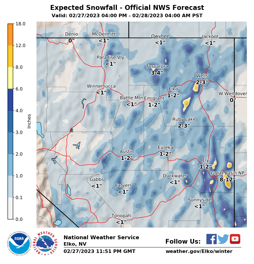
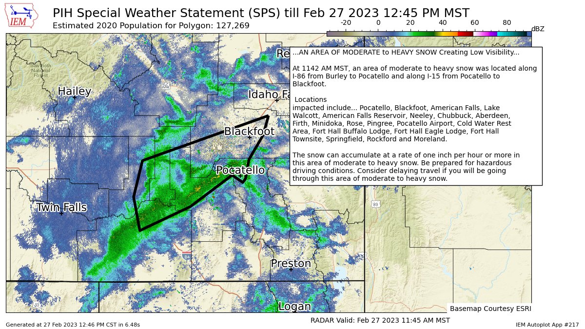
A band of snow is moving through the area from Burley to Pocatello bringing moderate to heavy snow with low visibilities. Please use caution when driving through this area. Current winter weather advisories & warnings are out for other areas south and east of this (SPS). #idwx

2
7

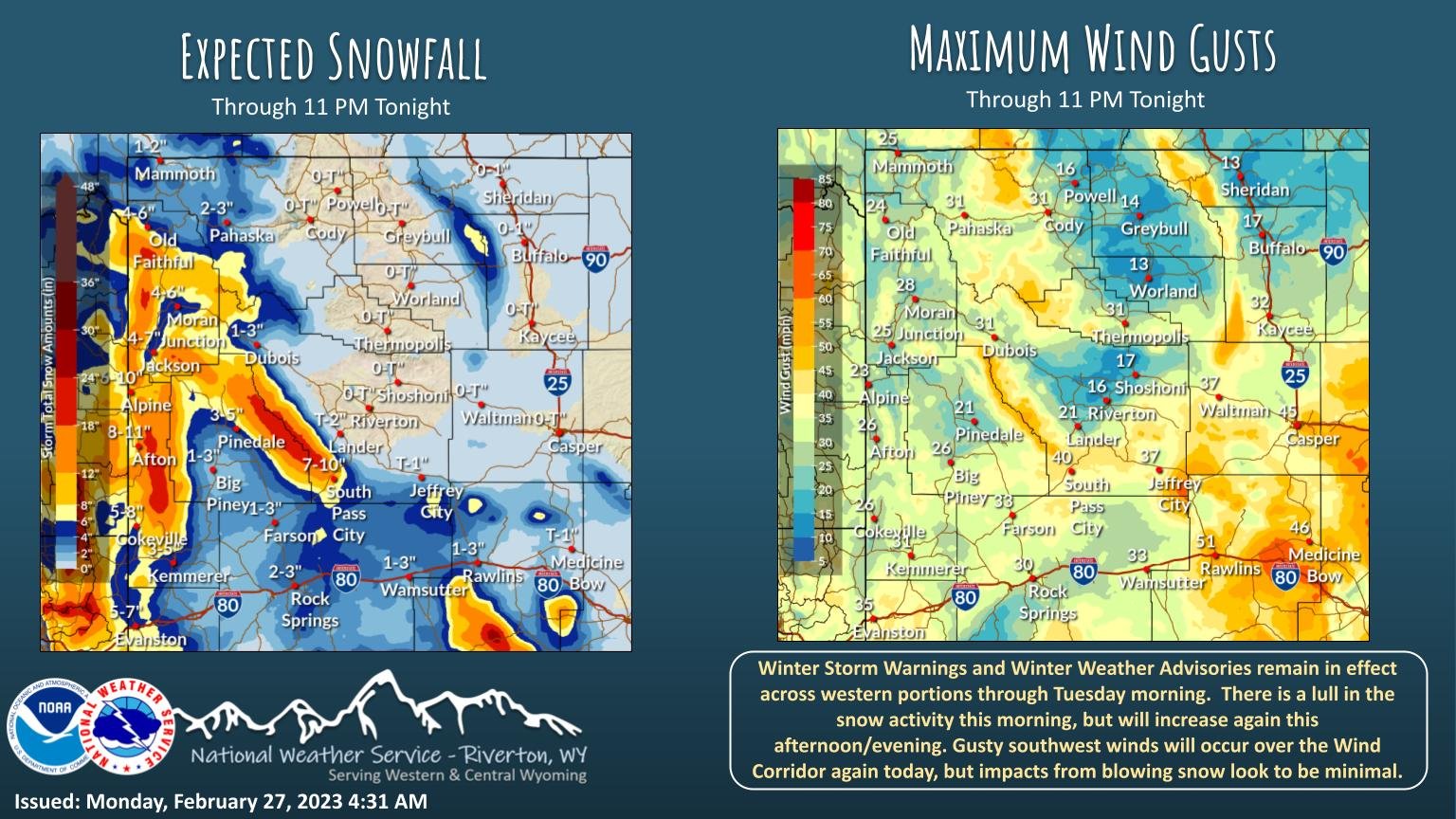
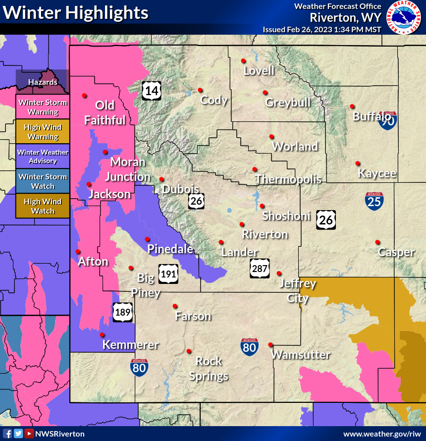
Winter Storm Warnings and Advisories remain in effect across western portions due to snowfall and very gusty winds. These gusty winds will also impact areas east of the Divide, including South Pass and from Rock Springs to Casper. #wywx
read image description
ALT
2
7
A Geomagnetic Storm Watch is in effect for today, Feb 27 (G3: Strong) and Tue, Feb 28 (G2: Moderate). Possible impacts to: power systems, spacecraft, GPS, LF/HF radio. See spaceweather.gov for updated info. #spaceweather #aviation
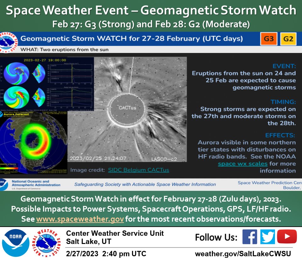
2
Minor impacts from snow are expected across northern Utah valleys, north of Salt Lake County, through 8 AM Tuesday. #utwx

1
8
26
Moderate Impacts from snow and wind are expected across northern Utah mountains and mountain valleys through 5 PM Wednesday. Plan accordingly. #utwx
1
7
29

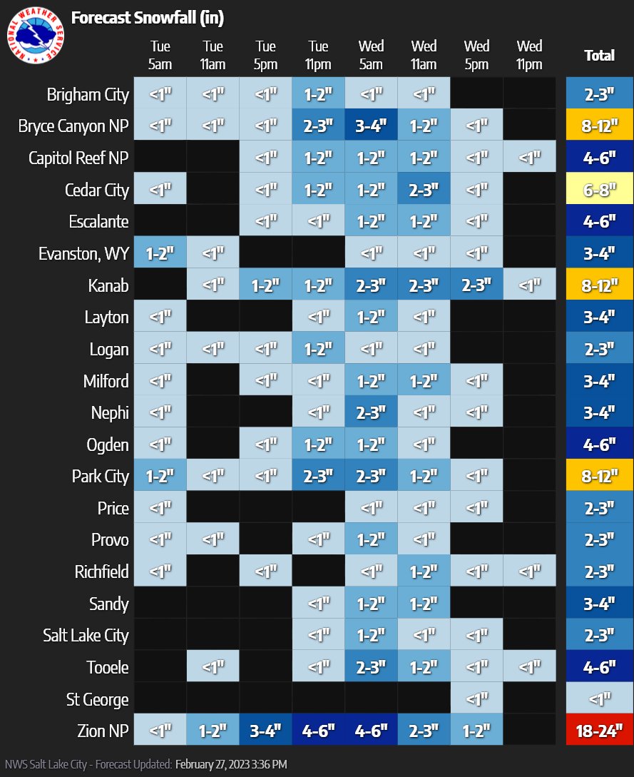
Here is the latest on the winter storm over the west. The graphics are the latest winter highlights (notice valley locations have been added) and the expected snow totals through Tuesday evening. #wywx
1
4
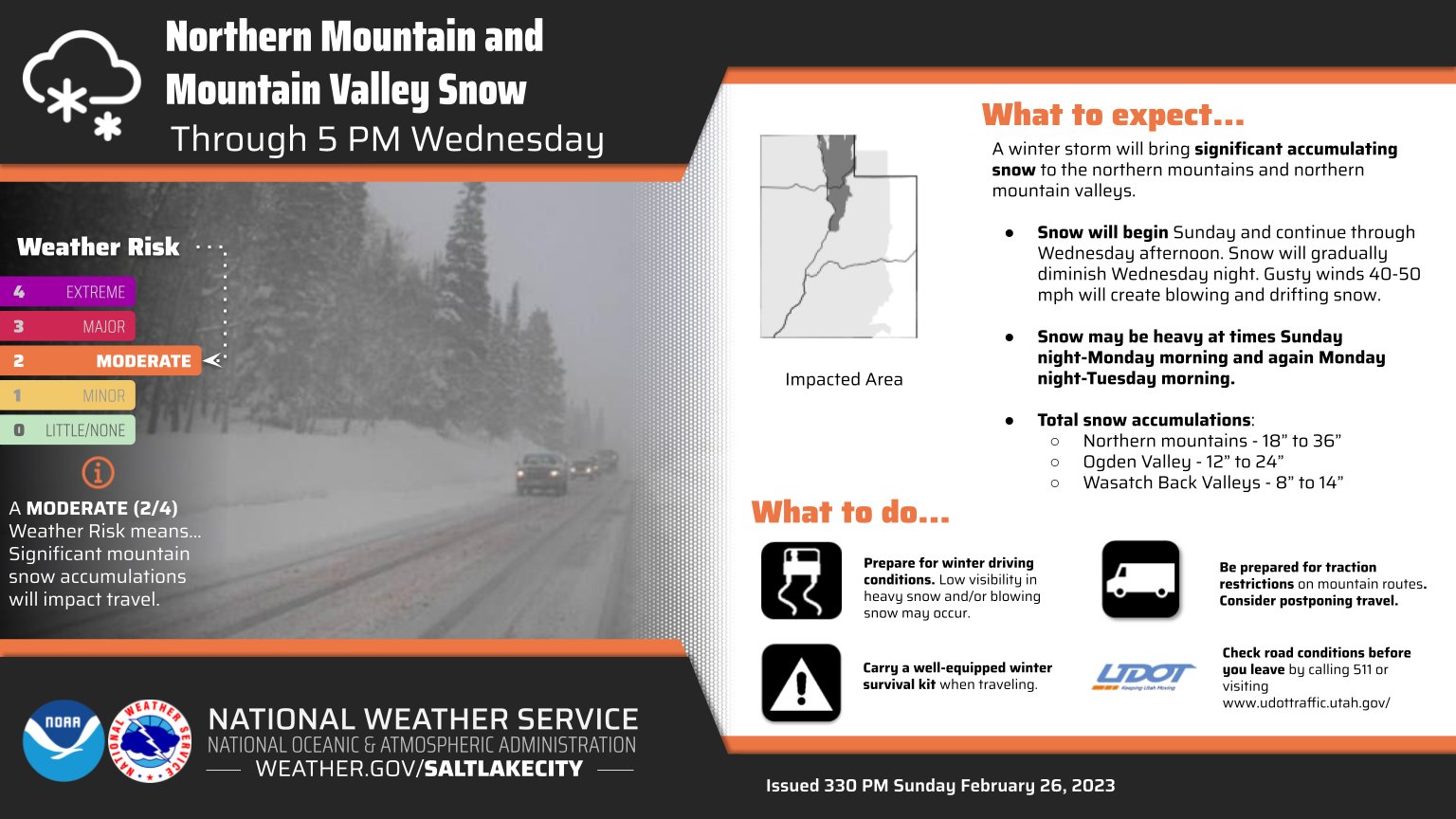
🌨️👇(1/3) Winter Storm Warnings:
📍Mountains/mountain valleys of northern Utah
🕑Through 5 PM Wednesday
❄️🌬️18-36" w/winds gusting up to 50 mph in the mountains
❄️🌬️12-24" Ogden Valley w/the Wasatch Back seeing lesser amounts of 8-14" & winds gusting near 40 mph.
#utwx

2
12
85
Show this thread