Portal:Somerset
The Somerset Portal

Somerset (/ˈsʌmərsɪt, -sɛt/ (![]() listen); archaically Somersetshire) is a county in South West England which borders Gloucestershire and Bristol to the north, Wiltshire to the east, Dorset to the south-east and Devon to the south-west. It is bounded to the north and west by the Severn Estuary and the Bristol Channel, its coastline facing southeastern Wales. Its traditional border with Gloucestershire is the River Avon. Somerset is formed of six districts, of which two are unitary authorities and its county town is Taunton.
listen); archaically Somersetshire) is a county in South West England which borders Gloucestershire and Bristol to the north, Wiltshire to the east, Dorset to the south-east and Devon to the south-west. It is bounded to the north and west by the Severn Estuary and the Bristol Channel, its coastline facing southeastern Wales. Its traditional border with Gloucestershire is the River Avon. Somerset is formed of six districts, of which two are unitary authorities and its county town is Taunton.
Somerset is a rural county of rolling hills, the Blackdown Hills, Mendip Hills, Quantock Hills and Exmoor National Park, and large flat expanses of land including the Somerset Levels. There is evidence of human occupation from Paleolithic times, and of subsequent settlement by the Celts, Romans and Anglo-Saxons. The county played a significant part in Alfred the Great's rise to power, and later the English Civil War and the Monmouth Rebellion. The city of Bath is famous for its Georgian architecture and is a UNESCO World Heritage Site. (Full article...)
Selected article

The low lying areas of the North Somerset Levels and Somerset Levels have been subject to thousands of years of flooding and man's attempts to control the flow of water. In the north of the county the Limestone of the Mendip Hills dominates the landscape, while in the south the Blackdown and Quantock Hills rise out of the levels. The highest areas are on Exmoor. The wide variety of landscapes has led to several areas being designated as Sites of Special Scientific Interest for geological reasons, and support a range of flora and fauna as can be seen from the List of Sites of Special Scientific Interest in Somerset (Full article...)
Selected biography -
John Wemyss "Jake" Seamer (23 June 1913 – 16 April 2006) was an amateur cricketer who played for Oxford University and Somerset either side of the Second World War. A bespectacled cricketer, Seamer was a right-handed batsman who played with a defensive streak to his game which was rarely seen among amateur batsmen of his time. He was described as a leg break googly bowler, but in truth he rarely bowled at all, and claimed just four first-class wickets.
Seamer played the best of his cricket while at Oxford University. All four of his first-class centuries were made for the university side, and his average for Oxford was 35.30, significantly higher than his career average of 20.35. He made his highest score against Free Foresters in his second year, during which he accrued 858 runs, more than double he managed in any other season. On completion of his studies at Oxford, Seamer joined the Sudan Political Service, which limited his first-class cricket appearances to periods of leave. He was named as one of three amateurs to captain Somerset in 1948, leading the team during June and July. That season was his last for Somerset, and he made only one further first-class appearance. He became a district commissioner in the Sudan, and after leaving the service, he taught at Marlborough College and was twice mayor of Marlborough. (Full article...)Districts of Somerset

- South Somerset
- Taunton Deane
- West Somerset
- Sedgemoor
- Mendip
- Bath and North East Somerset (Unitary)
- North Somerset (Unitary)
Subcategories
Related portals
Selected images

Weston-super-Mare Town Hall, the administrative headquarters of North Somerset (from Somerset)

A traditional cider apple orchard at Over Stratton, with sheep grazing (from Somerset)

Tyntesfield (from Somerset)

A steam locomotive and carriages, on the West Somerset Railway, a heritage line of notable length, in spring 2015 (from Somerset)

Brewhouse Theatre, Taunton (from Culture of Somerset)

Glastonbury Tor (from Culture of Somerset)

The Dunster Yarn Market was built in 1609 for the trading of local cloth. (from Somerset)

The Avon Gorge, the historic boundary between Gloucestershire and Somerset, and also Mercia and Wessex; Somerset is to the left (from Somerset)

Stone quarries are still a major employer in Somerset (from Somerset)

The west front of Wells Cathedral (from Culture of Somerset)
Glastonbury Tor (from Somerset)

The Exmoor landscape with the native Exmoor Pony (from Somerset)

The town of Glastonbury looking west from the top of Glastonbury Tor. The fields in the distance are the Somerset Levels. (from Somerset)

Sand Sculpture at Weston-super-Mare Sand Sculpture Festival of A Midsummer Nights Dream (from Culture of Somerset)
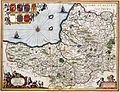
A map of the county in 1646, author unknown (from Somerset)
The west front of Wells Cathedral (from Somerset)

"Samurai" by Griffens CC, at Burnham on Sea Carnival 2006, part of the West Country Carnival circuit (from Culture of Somerset)

The River Brue in an artificial channel draining farmland near Glastonbury (from Somerset)
Tyntesfield. (from Culture of Somerset)

Bristol Airport, which is located in North Somerset (from Somerset)

Brean Down from Steep Holm (from Somerset)

The Huish Park ground of Yeovil Town F.C.. (from Culture of Somerset)


_down_South_Wales_Pullman.JPG)


_from_the_tor_arp.jpg)


.jpg)

Selected settlement

Co-ordinates 51°03′N 2°44′W / 51.05°N 2.74°W
Somerton is a small town and civil parish in the South Somerset district. It gave its name to the county of Somerset, was briefly, around the start of the 14th century, the county town, and around 900 AD was possibly the capital of Wessex. It has held a weekly market since the Middle Ages, and the main square with its market cross is today an attractive location for visitors. Situated on the River Cary, approximately 8.8 miles (14.2 km) north-west of Yeovil, the town has its own parish council serving a population of 4,706 as of 2002, and an acreage of 6,620 acres (2,680 ha) as of 1894. The civil parish includes the hamlets of Etsome and Hurcot.
The history of Somerton dates back to the Anglo-Saxon era, when it was an important political and commercial centre. A local legend has it that Ine, a Wessex king, was originally a farmer in Somerton. After the Norman conquest of England the importance of the town declined despite being the former county town of Somerset in the late thirteenth century and early fourteenth century. Despite losing county town status, Somerton then became a market town in the Middle Ages, whose economy was supported by transport systems using the River Parrett, and later rail transport via the Great Western Railway, and by light industries including glove making and gypsum mining.
In the centre of Somerton the wide market square, with its octagonal roofed market cross, is surrounded by old houses, while close by is the 13th century Church of St Michael and All Angels. Somerton also had links with Muchelney Abbey in the Middle Ages. (Full article...)
Did you know...
From Wikipedia's "Did You Know" archives:

- ... that Beckington Castle (pictured), built in the early 17th century, was not called a castle until 1839?
- ... that the Roman settlement at Gatcombe, in the modern English county of Somerset, may be the site of Iscalis described by Ptolemy?
- ... that some criminals were seen on television riding around Weston-super-Mare on an open-top bus?
- ... that Richmont Castle once overlooked the Chew Valley?
- ...that in 1737 cooper Charles Milsom discovered a spring in Lyncombe, Bath while fixing a fishpond, and styled himself as a doctor to market the spring water for its health-giving properties?
Things you can do
 |
Here are some tasks awaiting attention:
|
WikiProjects
Nearby projects: WikiProject Bristol, WikiProject Devon, WikiProject Dorset, WikiProject Wiltshire
Topics
Recognised content
| This is a list of recognized content, updated weekly by JL-Bot (talk · contribs). There is no need to edit the list yourself. If an article is missing from the list, make sure it is tagged (e.g. {{WikiProject Somerset}}) or categorized correctly. See WP:RECOG for configuration options. |
Featured articles
 Ælfheah of Canterbury
- Bath, Somerset
- Battle of Babylon Hill
- Battle of Marshall's Elm
- Margaret Bondfield
- Robert Burnell
- Chew Stoke
- Equestrian statue of Edward Horner
- Exmoor
- Ham Wall
- Herbie Hewett
- Kennet and Avon Canal
- Mells War Memorial
- Mendip Hills
- Lionel Palairet
- Porlock Stone Circle
- River Parrett
- Sieges of Taunton
- Somerset County Cricket Club in 2009
- Somerset Levels
- Somerset
- Sweet Track
- Marcus Trescothick
- Wells Cathedral
- Withypool Stone Circle
Featured lists
- List of ecclesiastical parishes in the Diocese of Bath and Wells
- Works of Keith Floyd
- Grade I listed buildings in Bath and North East Somerset
- Grade I listed buildings in Mendip
- Grade I listed buildings in North Somerset
- Grade I listed buildings in Sedgemoor
- Grade I listed buildings in South Somerset
- Grade I listed buildings in Taunton Deane
- Grade I listed buildings in West Somerset
- Grade II* listed buildings in North Somerset
- List of locks on the Kennet and Avon Canal
- List of civil parishes in Somerset
- List of English Heritage properties in Somerset
- List of Sites of Special Scientific Interest in Avon
- List of Sites of Special Scientific Interest in Somerset
- List of Somerset County Cricket Club Twenty20 players
- List of Somerset County Cricket Club grounds
- List of Somerset County Cricket Club players with 100 or more first-class or List A appearances
- List of churches preserved by the Churches Conservation Trust in Southwest England
- List of hillforts and ancient settlements in Somerset
- List of local nature reserves in Somerset
- List of scheduled monuments in North Somerset
- List of scheduled monuments in Sedgemoor
- List of scheduled monuments in South Somerset
- Grade II* listed buildings in Mendip
- List of museums in Somerset
- List of national nature reserves in Somerset
- List of National Trust properties in Somerset
- Scheduled monuments in Bath and North East Somerset
- Scheduled monuments in Mendip
- Scheduled monuments in Taunton Deane
- Scheduled monuments in West Somerset
- Grade II* listed buildings in Sedgemoor
- Grade II* listed buildings in Taunton Deane
- Grade II* listed buildings in West Somerset
Featured topics
Good articles
 A303 road
- 1754 Taunton by-election
- 1887 Taunton by-election
- The Abbot's Fish House, Meare
- Agapemonites
- William Arnold (settler)
- Ashton Court
- Ashton Court Festival
- Athelm
- River Avon, Bristol
- Avon Gorge
- Herbert E. Balch
- Barrington Court
- E. W. Bastard
- Bath Abbey
- Bath Assembly Rooms
- Beckford's Tower
- Berhtwald
- Birnbeck Pier
- Bishop's Palace, Wells
- Blackdown Hills
- Blagdon Lake
- John Braham (RAF officer)
- Brean Down
- HMS Bridgewater (L01)
- Bridgwater and Taunton Canal
- Bridgwater Bay
- Bridgwater
- Brislington House
- Bruton Dovecote
- Buildings and architecture of Bath
- Burnham-on-Sea
- Mike Burns (cricketer)
- Buro Happold
- Burrow Mump
- Burton Pynsent House
- Jos Buttler
- Jenson Button
- Cadbury Camp
- Cadbury Castle, Somerset
- Chard, Somerset
- Cheddar Gorge
- Cheddar, Somerset
- Chew Magna
- St Andrew's Church, Chew Stoke
- Claverton Pumping Station
- Cleeve Abbey
- Clevedon
- Clevedon Court
- Clevedon Pier
- Cleveland Pools
- Clifton Suspension Bridge
- Climate of south-west England
- Coleridge Cottage
- The Crescent, Taunton
- Crewkerne
- Cricket at the 1900 Summer Olympics
- Crook Peak to Shute Shelve Hill
- Dolebury Warren
- Dovecot at Blackford Farm
- Dunkery Hill
- Dunstan
- Dunster Butter Cross
- Dunster Castle
- Dunster
- Dunster Working Watermill
- Ebbor Gorge
- Exmoor pony
- Farleigh Hungerford Castle
- Reginald Fitz Jocelin
- Savaric FitzGeldewin
- Henry Fownes Luttrell (died 1780)
- Harry Fox (sportsman)
- Frome
- Fyne Court
- Gallox Bridge, Dunster
- Edith Garrud
- Geography of Somerset
- Geology of Somerset
- Gisa (bishop of Wells)
- Glastonbury Abbey
- Glastonbury Canal
- Glastonbury Festival
- Glastonbury
- Glastonbury Lake Village
- Glastonbury Tor
- Grade I listed buildings in Somerset
- Grand Western Canal
- HM Prison Shepton Mallet
- Hestercombe House
- James Hill (British Army officer)
- Sidney Hill
- History of Somerset
- Holnicote Estate
- Hot Fuzz
- Jocelin of Wells
- John of Tours
- Keynsham
- King Alfred's Tower
- King John's Hunting Lodge, Axbridge
- Scott Laird
- Leigh Court
- Leigh Woods National Nature Reserve
- Long Ashton railway station
- Lytes Cary
- Masonic Hall, Taunton
- Midsomer Norton
- Minehead
- Monmouth Rebellion
- Montacute House
- Muchelney Abbey
- Nailsea Court
- Nailsea
- Nailsea and Backwell railway station
- Nettlecombe Court
- Stephen Newton
- Tom Nichols (footballer)
- Nunney Castle
- Pill railway station
- Portishead, Somerset
- Massey Poyntz
- The Priest's House, Muchelney
- Prior Park Landscape Garden
- Prior Park
- Pulteney Bridge
- Quantock Hills
- Radstock
- River Brue
- River Tone
- Robert of Bath
- Roman Baths (Bath)
- Royal Crescent
- Ted Sainsbury
- St Catherine's Court
- Sand Point and Middle Hope
- Scheduled monuments in Somerset
- Jake Seamer
- Shepton Mallet
- Sir Bevil Grenville's Monument
- Solsbury Hill
- Somerset Coal Canal
- Somerset Coalfield
- Somerset County Cricket Club in 1882
- Somerset County Cricket Club in 1885
- Somerton, Somerset
- South West Coast Path
- Stanton Drew stone circles
- Steep Holm
- Stembridge Mill, High Ham
- Stoke sub Hamdon Priory
- Ston Easton Park
- Stoney Littleton Long Barrow
- Street, Somerset
- Sutton Court
- Sydney Gardens
- St Joseph's Convent, Taunton
- Taunton
- Taunton Unitarian Chapel
- Team Bath F.C.
- Theatre Royal, Bath
- Tintinhull Garden
- Treasurer's House, Martock
- Hugh Trenchard, 1st Viscount Trenchard
- The Tribunal, Glastonbury
- Tyntesfield
- Vicars' Close, Wells
- Walton and Ivythorn Hills
- Watchet
- Wellington Monument, Somerset
- Wellington, Somerset
- Hugh of Wells
- Wells, Somerset
- West Hendford Cricket Ground
- West Pennard Court Barn
- West Somerset Mineral Railway
- Westhay Moor
- Weston-super-Mare
- Westonzoyland Pumping Station Museum
- Edward Wickham
- Maisie Williams
- Woodspring Priory
- Wookey Hole Caves
- Worle railway station
- Worlebury Camp
- Wulfhelm
- Yarn Market, Dunster
- Yatton railway station
- Yeovil
Good topics
Associated Wikimedia
The following Wikimedia Foundation sister projects provide more on this subject:
-
 Commons
Free media repository -
 Wikibooks
Free textbooks and manuals -
 Wikidata
Free knowledge base -
 Wikinews
Free-content news -
 Wikiquote
Collection of quotations -
 Wikisource
Free-content library -
 Wikiversity
Free learning tools -
 Wikivoyage
Free travel guide -
 Wiktionary
Dictionary and thesaurus